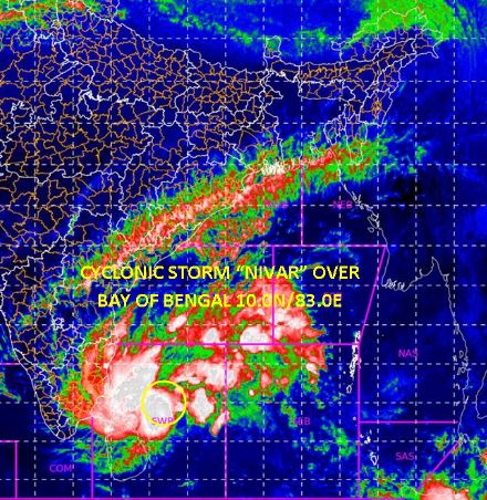
Bhubaneswar: The India Meteorological Department (IMD) said Tuesday that the deep depression over the Bay of Bengal has intensified into a cyclonic storm named ‘Nivar’.
“The deep depression over Southwest Bay of Bengal and the neighbourhood remained practically stationary during the past six hours and rapidly intensified into the cyclonic storm ‘Nivar’”, IMD clarified in his statement.
The cyclonic storm is likely to intensify further into a ‘severe’ cyclonic storm during the next 12 hours and into a ‘very severe’ cyclonic storm by November 25 evening when it will cross the Tamil Nadu and Puducherry coasts.
Cyclonic storm 'NIVAR' over Bay of Bengal lay centred at 0830 hrs IST of 24th Nov, about 410 km east-se of Puducherry. To intensify further into a SCS during next 24 hrs. To cross Tamil Nadu and Puducherry coasts during 25th Nov evening as SCS with a wind speed of 100-110 kmph. pic.twitter.com/eBLegDgOXg
— India Meteorological Department (@Indiametdept) November 24, 2020
Wind speeds ranging from 65 to 75 km/hr gusting to 85 km/hr are likely to prevail off Tamil Nadu coast. As the cyclone would inch closer to the coast and enter the ‘severe’ category, winds with speeds of 100 to 110 km/ hr gusting to 120 km/hr has been predicted over north Tamil Nadu, Puducherry, Karaikal.
Even though there will be no direct impact of the cyclonic storm on Odisha, the state is bracing for heavy rain under the influence of severe cyclonic storm Nivar between November 26 and 27.
The IMD regional centre in its afternoon bulletin said that light rain or thundershower likely to occur at one or two places over the districts of Koraput, Rayagada, Gajapati and dry weather very likely to prevail over the rest districts of Odisha.
“The system is likely to intensify into a severe cyclonic storm during the next 24 hours. It is likely to move west-northwest wards for the next 12 hours and then northwest wards,” said IMD in a statement.
As per IMD officials, the severe cyclonic storm will cross Tamil Nadu and Puducherry coasts between Karaikal and Mamallapuram around November 25 evening.
PNN
