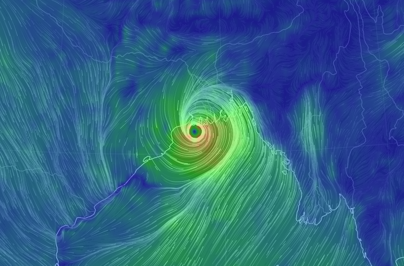
New Delhi: Cyclone Nivar is currently hovering over southwest Bay of Bengal and is likely to intensify further into a “very severe” cyclonic storm by 5.30 p.m., the MHA said on Wednesday.
The cyclone is very likely to move west northwestwards and cross Tamil Nadu and Puducherry coasts between Karaikal and Mamallapuram around Puducherry during Wednesday midnight and early hours Thursday as a very severe cyclonic storm with a wind speed of 120-130 kmph gusting to 145 kmph.
Ministry of Home Affairs (MHA) shared the information on Wednesday based on 11.30 a.m. report of the Cyclone Warning Division of the India Meteorology Department (IMD).
As per the latest report, the cyclone moved west-northwestwards with a speed of 11 kmph during past six hours and lay centred at 8.30 a.m. on Wednesday over southwest Bay of Bengal about 240 km east-southeast of Cuddalore, about 250 km east southeast of Puducherry and 300 km south southeast of Chennai.
“It is very likely to intensify further into a very severe cyclonic storm during next six hours,” the IMD release said around 11.30 a.m.
Fairly widespread rainfall and thunderstorm activity is very likely over coastal and north interior Tamil Nadu, Puducherry and Karaikal, south coastal Andhra Pradesh and Rayalaseema during Wednesday and Thursday, and southeast Telangana during Thursday.
Extremely isolated heavy rainfall activity is also very likely over coastal and north interior Tamil Nadu and Puducherry on Wednesday. Thanjavur, Tiruvarur, Nagapattinam, Cuddalore, Chennai, Kanchipuram, Chengalpattu, Myladuthirai, Ariyalur, Perambalur, Kallakurchi, Villupuram, Tiruvannamalai, Puducherry and Karaikal districts are to be affected.
The cyclone will affect Nellore and Chittoor districts of Andhra Pradesh on Wednesday and move over Rayalaseema and southeast Telangana on Thursday.
Gale wind speed reaching 105-115 kmph gusting to 130 kmph is prevailing over Southwest Bay of Bengal. It would further increase becoming 120-130 kmph gusting to 145 kmph during Wednesday afternoon to early hours on Thursday.
Squally wind speed reaching 55-65 kmph gusting to 75 kmph is prevailing along and off Tamil Nadu, Puducherry and adjoining South Andhra Pradesh coast and over Gulf of Mannar.
The wind will gradually increase and become gale wind speed reaching 120-130 kmph gusting to 145 kmph along and off coastal districts of north Tamil Nadu and Puducherry (Nagapattinam, Karaikal, Myladuthurai, Cuddalore, Puducherry, Villupuram and Chengalpattu) and 80-90 gusting to 100 kmph very likely over Tiruvarur, Kanchipuram, Chennai, Tiruvallur districts during Wednesday afternoon to early Thursday hours.
Sea condition is very high over Southwest Bay of Bengal and very rough to high along and off Tamil Nadu, Puducherry, south Andhra Pradesh coasts and over Gulf of Mannar. It would gradually become phenomenal over Southwest Bay of Bengal and along and off north Tamil Nadu, Puducherry coasts during Wednesday afternoon and early hours on Thursday.
Tidal wave of about 1-1.5m height above the astronomical tide is very likely to inundate the low-lying areas of north coastal districts of Tamil Nadu and Puducherry near the place of landfall.
Damage expected over Nagapattinam, Myladuthurai, Cuddalore, Villupuram and Chengalpattu districts of Tamil Nadu and Karaikal and Puducherry. Potential threat from flying objects.
The cyclone will lead to disruption of railways, overhead powerlines and signalling systems. There are expectations of widespread damage to standing crops, plantations and orchards.
“Small boats, country crafts may get detached from moorings. Visibility may be severely affected,” warns IMD, suggesting “total suspension of fishing operations and mobilise evacuation from coastal areas.”
It was advised to move coastal hutment dwellers to safer places. The IMD advised people in affected areas to remain in safe places and indoors, warning that movement in motor boats and small ships is unsafe.
In view of the current Covid-19 scenario, the MHA said that the NDRF teams are equipped with appropriate Personal Protective Equipment (PPE).
“NDRF is working in close coordination with district and local administrations. Awareness programmes are being conducted for all citizens in the form of information about cyclones, ‘Dos and Don’ts’ and information about Covid-19 in affected areas and prevention measures.”
All deployed teams are assisting the local administration in evacuation of people from areas that are likely to be affected by the cyclone, said the Ministry.
IANS
