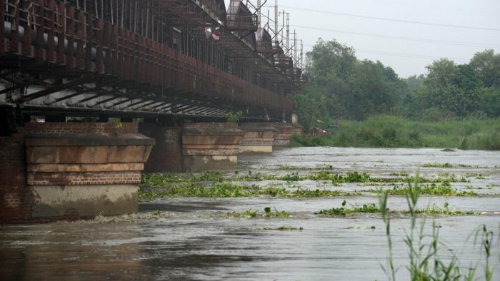
New Delhi: The torrential Yamuna in Delhi swelled to a staggering 208.48 metres Thursday morning, inundating nearby streets and public and private infrastructure, and causing immense hardships to people living in close proximity to the river.
The water level at the Old Railway Bridge crossed the 208-metre mark Wednesday night and rose to 208.48 metres by 8 am Thursday. It is expected to rise further, according to the Central Water Commission, which has termed it an “extreme situation”.
With the situation deteriorating every passing hour, Chief Minister Arvind Kejriwal urged the Centre to intervene and the city police imposed Section 144 of the CrPC in flood-prone areas to prevent unlawful assembly of four or more people and public movement in groups.
Lt Governor V K Saxena has also called a meeting of the Delhi Disaster Management Authority Thursday.
Delhi Chief Minister Arvind Kejriwal Thursday announced closure of schools in areas inundated with floodwater.
“All government and private schools are being closed in areas of Delhi where water is filling up,” Kejriwal said in a tweet in Hindi.
In a letter to Union Home Minister Amit Shah, Kejriwal requested that the water from Hathnikund barrage in Haryana be released slowly and pointed out that Delhi is set to host the G20 Summit meeting in a few weeks.
“The news of flooding in the capital of the country will not send a good message to the world. Together we will have to save the people of Delhi from this situation,” he said.
There are two major barrages on the Yamuna — Dakpathar in Dehradun and Hathnikund in Yamunanagar, upstream of Delhi. There are no dams on the river and, therefore, most of the monsoon flow remains unutilised, resulting in floods during the season.
Delhi recorded a rapid increase in the Yamuna’s water level over the past three days.
It shot up from 203.14 metres at 11 am Sunday to 205.4 metres at 5pm Monday, breaching the danger mark of 205.33 metres 18 hours earlier than expected.
The river exceeded the evacuation mark of 206 metres Monday night, prompting the relocation of people residing in flood-prone areas to safer locations and the closure of the Old Railway Bridge for road and rail traffic. The water level breached the previous all-time record of 207.49 metres by 1 pm Wednesday and the 208-metre mark by 10 pm.
Major floods in Delhi occurred in 1924, 1977, 1978, 1988, 1995, 1998, 2010 and 2013. An analysis of flood data from 1963 to 2010 indicates an increasing trend for floods occurring in September, and a decreasing trend in July, according to research.
According to the CWC, the flow rate at the Hathnikund barrage remained above 1.5 cusecs at night.
Normally, the flow rate at the barrage is 352 cusecs, but heavy rainfall in the catchment areas increases the discharge. One cusec is equivalent to 28.32 litres per second.
The India Meteorological Department has predicted heavy rain in Uttarakhand and Uttar Pradesh Thursday and Friday, raising concern about a further rise in the water level in the rivers.
Jammu and Kashmir, Himachal Pradesh, Punjab and Haryana recorded “heavy to extremely heavy” rainfall over three days from Saturday. This resulted in overflowing rivers, creeks and drains that have massively damaged infrastructure and disrupted essential services.
Delhi witnessed its highest rainfall (153 mm) in a single day in July since 1982 in the 24-hour period ending at 8.30 am Sunday. The city received an additional 107 mm of rainfall in the subsequent 24 hours, exacerbating the situation. The heavy rain transformed roads into gushing streams, parks into watery labyrinths and marketplaces into submerged realms.
The Yamuna River system’s catchment covers parts of Uttar Pradesh, Uttarakhand, Himachal Pradesh, Haryana, Rajasthan, Madhya Pradesh and Delhi.
The low-lying areas near the river in Delhi, inhabited by around 41,000 people, are considered prone to flooding. Encroachments on the river’s floodplain have occurred over the years, despite the land belonging to the Delhi Development Authority, the revenue department and private individuals.
The city’s northeast, east, central, and southeast districts are most affected by floods in the city. A study on ‘Urban Flooding and its Management’ by the Irrigation and Flood Control Department identifies east Delhi under the floodplain region and highly vulnerable to floods.
The Yamuna breached the danger mark twice in September last year, with the water level reaching 206.38 metres.
In 2019, the river witnessed a peak flow rate of 8.28 lakh cusecs August 18-19 and the water level rose to 206.6 metres. In 2013, it reached a level of 207.32 metres.
