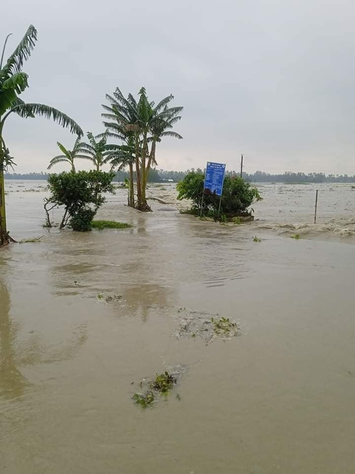
New Delhi: Heavy rain disrupted daily life in vast swathes of north India including Himachal Pradesh and Uttarakhand on Friday while the flood situation in Assam remained grim with major rivers flowing above the danger mark and nearly 22 lakh people affected.
Assam Chief Minister Himanta Biswa Sarma visited several flood-hit areas in Dibrugarh, one of the 29 affected districts in the state which is reeling under the worst deluge in recent years.
In Uttarakhand, which has received heavy rain over the past few days, a five-year-old drowned in a rainwater-filled pit in Dehradun and a teenager in a Haridwar rivulet.
Normal life was disrupted in the hill state as the rains triggered numerous landslides, blocking key roads including the national highway leading to Badrinath.
Heavy rain also lashed several parts of Himachal Pradesh in the past 24 hours, leading to the closure of 64 roads. The regional Met office warned of moderate flash flood risk in few areas of Kangra, Kullu, Kinnaur, Mandi, Sirmaur and Shimla districts in the next 24 hours.
In Rajasthan, heavy rain continued to batter the state with Malpura in Tonk district recording 176 mm rainfall in a 24-hour period.
In Assam, 77 wild animals have died — either due to drowning or during treatment — while 94 have been rescued from the flooded Kaziranga National Park as on Friday, an official said.
The flood situation was critical with nearly 22 lakh people affected in 29 districts and all major rivers flowing above the danger mark.
Chief Minister Sarma reviewed the situation in Dibrugarh town, which has been under water and facing severe power shortages for the past eight days. He visited some areas on foot and interacted with the people.
The toll in this year’s flood, landslide and storm has risen to 62, while three persons are missing.
Among the worst-hit districts are Dhubri where 6.48 lakh people are affected, Darrang with 1.90 lakh people hit and Cachar with 1.45 lakh people affected.
Meanwhile, the Delhi government has set up a 24X7 flood control room to monitor real-time data from the Hathnikund barrage from where water is released in the Yamuna to Delhi.
“Last year, the Yamuna reached its highest level in 70 years. The Delhi government is gearing up to tackle any possibility of floods. The control room is in touch with officials at Hathnikund barrage from where Yamuna river discharge is received. After the release of one lakh cusecs of water, relief and rescue machinery starts working,” Atishi said, the city government’s water minister.
Bharadwaj, the irrigation and flood control minister, said the control room would monitor data in real time and be entirely computerised.
As soon as more than one lakh cusecs of water is released from the barrage, all agencies — including the flood control department — will be activated, Aitshi said.
The Met office has predicted generally cloudy skies with light rain, accompanied by thunderstorms and lightning, on Saturday. It has also forecast heavy rainfall during the next four to five days.
In Uttarakhand, meanwhile, the State Emergency Operation Centre said landslides had blocked 88 rural motorable roads, two border roads, one state highway and the national highway leading to the Badrinath temple.
The Rishikesh-Badrinath National Highway was blocked at Lambagad — an area highly vulnerable to landslides.
In Rudraprayag district, debris from a landslide blocked the opening of an old tunnel on Friday. However, no casualties were reported, Superintendent of Police Vishakha Ashok Bhadane said.
Continuous intermittent heavy rain in Dehradun had left many roads waterlogged.
Neighbouring Himachal Pradesh, meanwhile, has already 59 per cent excess rain in July at 43.2 mm against a normal of 27.2 mm.
Sixty-four roads, including 55 in Mandi, seven in Chamba and one each in Kangra and Shimla districts, are closed for traffic following torrential rain, the emergency operation centre said.
The Met office in Shimla has issued a ‘yellow’ alert for heavy rain, thunderstorm and lightning at isolated places on Saturday.
In Rajasthan, 116 mm of rainfall was recorded in Sajangarh (Banswara), 107 mm in Tijara, 101 mm in Danpur, 102 mm in Nainwan (Bundi), 97 mm in Thanagazi, 90 mm in Pipalda (Kota), 88 mm in Tapukda, and 82 mm in Fagi of Jaipur.
Many parts received moderate to heavy rainfall in a 24-hour period, the weather office said.
A circulation system over southwestern Uttar Pradesh and adjoining eastern Rajasthan contributed to the heavy rain, with the monsoon trough line passing through Bikaner and Sikar.
Heavy rain is likely to continue in eastern Rajasthan on Saturday, which could decrease subsequently on Sunday and Monday.
Rainfall activity is expected in some parts of northeastern Rajasthan on Sunday and Monday and could increase on July 9-10.
Bikaner division and eastern and northern parts of Jodhpur division are also expected to receive rain in the next two to three days, the weather office said.
Rain-drenched northern West Bengal is likely to receive more showers till July 9, the Met office said.
A trough from Rajasthan to the northeast and an active monsoon over northern West Bengal is likely to bring heavy rainfall in the region, it said.
Heavy to very heavy rain with extremely heavy rain in one or two places is likely in the sub-Himalayan districts of Darjeeling, Kalimpong, Jalpaiguri, Alipurduar and Coochbehar, the Met said in a special bulletin.
The downpour may cause landslides in the hill districts of Darjeeling and Kalimpong and waterlogging of low-lying areas in the plains.
Water levels of rivers such as Teesta, Jaldhaka, Sankosh and Torsa may rise owing to heavy rain, it added.
Meghalaya received 44 per cent excess rains in the last one month, causing large-scale damage to public infrastructure and upending the lives of people, officials said.
The state received 117.32 cm of rain between June 1 and July 3, which was 44 per cent higher than normal, a senior disaster management official said.
“The southern districts of the state are the worst affected,” he said.
PTI
