
Bhubaneswar: Though the IMD has not so far revealed the possible place of the landfall of the likely cyclone which will turn into a severe cyclonic storm October 24, the weather agency issued the graphics of the possible track of its moment. This indicated that a severe cyclonic storm could likely hit the north Odisha coast, a senior scientist at the Regional Meteorological Centre, Bhubaneswar said.
IMD DG Mrutyunjay Mohapatra Sunday said that Odisha is likely to bear the maximum brunt of the cyclonic storm. The cyclone would spend maximum time on the Odisha coast leading to heavy to very heavy rainfall and high speed wind up to 100 km/hour.
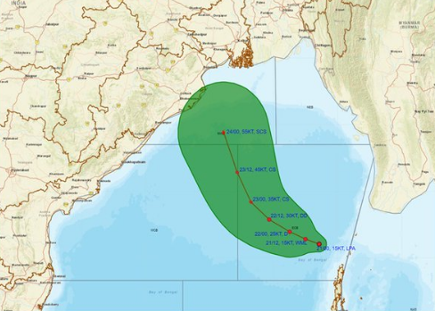
Currently, the cyclonic circulation over the Andaman Sea Monday intensified into a low-pressure area and is likely to turn into a cyclonic storm by October 23 which will impact Odisha-West Bengal coast, the IMD said.
The India Meteorological Department in a special message said Sunday’s upper air cyclonic circulation over North Andaman Sea and the adjoining Bay of Bengal has formed a low-pressure area over the eastcentral Bay of Bengal and adjoining north Andaman Sea in the early morning.
“It is very likely to intensify into a depression by October 22 morning and into a cyclonic storm by October 23, over eastcentral Bay of Bengal,” the IMD said.
The system is very likely to reach northwest Bay of Bengal off the Odisha-West Bengal coasts by October 24 morning, it said.
READ MORE | Cyclonic storm likely to hit Odisha-West Bengal coasts by Oct 24: IMD
The IMD has advised fishermen to return to shore by Monday evening and not to venture into the sea till October 26.
The weather agency has forecast light to moderate rainfall at most places with heavy rainfall at isolated places in Odisha October 23. Heavy to very heavy rainfall may also occur at a few places with extremely heavy rainfall at isolated places October 24-25.
The IMD has issued red warning (take action) of isolated heavy to very heavy rainfall (7 to 20 cm) with isolated extremely heavy rainfall (more than 20 cm) and thunderstorm with lightning has been sounded for isolated places in Puri, Khurda, Ganjam and Jagatsinghpur districts October 24.
It also issued an orange warning (get ready to take action) of heavy to very heavy rainfall (7 to 20cm) along with thunderstorm with lightning for isolated places in Kendrapada, Cuttack, Nayagarh, Kandhamal and Gajapati districts.
Yellow warning (be aware) of heavy rainfall (7 to 11cm) and thunderstorm with lightning has also been issued for isolated places in Bhadrak, Balasore, Jajpur, Angul, Dhenkanal, Boudh, Kalahandi, Rayagada, Koraput, Malkangiri, Mayurbhanj and Keonjhar districts.
The IMD maintained that squally wind speed reaching 40-50 gusting to 60 kmph is very likely to commence over northwest adjoining west central Bay of Bengal, along and off Odisha coast, from October 23 evening. It would gradually increase becoming gale wind speed reaching 100-110 kmph gusting to 120 kmph from October 24 night till October 25 morning.
Meanwhile, the Odisha government has put the district collectors of coastal districts on high alert and directed them to take all possible measures including evacuation of people from vulnerable places.
PTI