Bhubaneswar/Sambalpur: Odisha may encounter a low flood in the Mahanadi river basin due to heavy downpours in the upper catchment areas and high water inflow in the Hirakud reservoir, officials said Saturday.
The situation may exacerbate as another low-pressure area has formed over the northern Bay of Bengal and can intensify into a depression, prompting the Met office to issue a red alert of torrential rain in many districts.
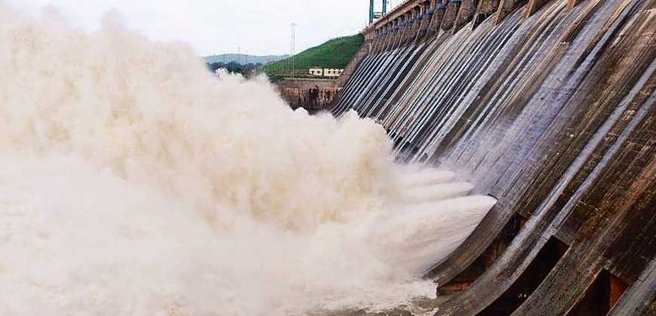
Fourteen more gates of the Hirakud dam in western Odisha’s Sambalpur district were opened in four phases during the day to release excess water into the Mahanadi’s downstream areas in the state, which was pounded by heavy rain over the past few days due to depression.
At 7 pm, about 5.64 lakh cusecs of water, against an inflow of 5.3 lakh cusecs, was discharged through 34 gates.
The water level stood at 617 feet in the reservoir, which has a maximum storage capacity of 630 ft, Water Resources engineer-in-chief Bijay Kumar Mishra told reporters, adding that they would try to bring down the level to 616 ft.
He said 6 lakh cusecs of water would reach Mundali in Cuttack district on Sunday morning and over 7 lakh cusecs on Monday morning. The water released from Hirakud, the longest earthen dam of the world, generally takes 36 hours to reach the area, which had a flow 3.42 lakh cusecs at 6 pm.
The Mahanadi, having a length of 494 km and a drainage area of 65,580 square km in the state, is also getting additional water from the Hati river and Tel tributary.
“After considering today’s situation, we think that there can be a small level of flood in the Mahanadi system if more water is needed to be released on the basis of the rain situation in upper catchment areas and Chhattisgarh,” Mishra said.
The Baitarani river was flowing at 18.14 metres at 6 pm at Akhuapada in Bhadrak against the danger level of 17.83 m. The Jalaka river in Balasore was also flowing at 6.31 m against the danger mark of 5.5 m.
The water level is rising in the many rivers, including Mahanadi and some of its tributaries, Subarnarekha, Banshadhara and Rushikulya, but below the danger level, the official said
Sambalpur was battered by 129.2 mm of rain between 8.30 am and 5.30 pm, followed by 80.8 mm in Hirakud and 79 in Bargarh, the Bhubaneswar Meteorological Centre said.
Balasore recorded 45.8 mm of rain, while Jagatsinghpur and Puri received 76 mm and 61 mm of showers, respectively. Incessant light rain has occurred in Bhubaneswar and Cuttack since the morning.
Water Resources superintendent engineer Prabhas Pradhan said they were keeping a close watch on the situation in Jalaka and were ready to tackle any possible breach of embankments.
The Sambalpur-Subarnapur road is cut off due to the floodwater overflowing at Gunderpur bridge, but no area is marooned, Collector Ananya Das said.
The Sambalpur administration evacuated at least 1,000 people from low-lying areas near the dam following heavy rain in upper catchment areas and sheltered them at seven flood centres, she added.
Hirakud chief engineer Anand Chandra Sahu alleged lack of cooperation from Chhattisgarh, saying the Kalma barrage authority was not passing information on the discharge of floodwater from their point.
Sahu said that the situation was being managed at Hirakud on the basis of the data from the Central Water Commission.
“We’re monitoring the situation round the clock. The inflow is high and we have to open more gates if it increases,” he said.
Mishra said that the neighbouring state requested Odisha to open more gates due to heavy rain in the upper Mahanadi basin there.
“We will do it after reviewing the inflow, water level, safety of the Hirakud and the flood situation in lower catchment areas,” he said.
The administration is following the standard operating procedures for flood control in Sambalpur and other districts on the Mahanadi bank. It is taking steps to clear the excess water from the medium reservoirs and bring down the storage level to 75 per cent in view of the anticipated heavy rain.
The Water Resources Department has deputed senior officials to seven districts, cancelled leaves and put the coastal division on alert.
The low-pressure area, which formed in the morning, is set to move northwestwards and become well-marked during the next 12 hours. The system is expected to concentrate into a depression during the subsequent 24 hours, the Met said.
It issued a red warning of extremely heavy rain in Cuttack, Puri, Bhadrak, Dhenkanal, Jagatsinghpur, Jajpur and Kendrapara districts till Sunday morning.
Extremely heavy downpour is in forecast for Sambalpur, Subarnapur, Angul Bargarh, Bolangir, Boudh, Deogarh, Jharsuguda, Kalahandi and Nuapada on Sunday.
It may lead to a significant rise in the water level of rivers, flash flood, landslides, inundation of low-lying areas and agricultural fields, besides damage to houses and roads.
The weather office warned of heavy to very heavy rain in the rest of the districts till Monday morning.
Fisherfolks have been advised not to venture off the coast till Monday as the sea will be rough and wind speed of 45-65 kmph is expected over the west-central Bay of Bengal.
The Met asked farmers to suspend the use of fertilisers and pesticides for three-four days and make arrangements for drainage of excess water from the land.
PTI


