
While travelling, you must have noticed some stones along the road and top part of the stones are painted red, green, yellow and black while the bottom part is painted white. Apart from the name of the city, many other types of information are written in these stones.
These stones along the road are known as Milestone. These stones have a lot of importance. Milestones are the colorful stones we find on the side of highways and village roads notifying the distance to a location. Often getting neglected owing to the GPS-enabled smartphones these days, there was a time when these stones were the most reliable source of information about the kilometres you need to cover to reach your destination.
These stones along the road have different meanings. But do you know why these stones are of different colours? Although not much attention is paid to anything other than the distance, you should know that these stones of different colours are very useful.
Yellow strips on national highways: National highways of India span in more than one state. They provide connectivity between cities of different states. As per the record of 2015-2016, the length of national highways in India stands at 1.01 lakh km.
If you see a yellow stripped milestone on the side of the road, that means, you are on a national highway.
NS-EW corridor (north-south corridor– Jammu and Kashmir to Kanyakumari, east-west corridor– Porbandar to Silchar in Assam) and Golden Quadrilateral (connecting four metro cities in India– Delhi, Mumbai, Chennai and Kolkata) are also part of national highways.
Green strips on state highways: State highways connect different cities of a state. As per the record of 2015-2016, the total length of state highways in the country stands at 1.76 lakh km.
If you see a green stripped milestone on the side of the road, that means, you are on a state highway. These highways are constructed and administered by state governments.
Blue or black and white strips on city or main district road: If you see a blue stripped milestone or a black and white one, you are travelling in a city or on a district road. As the name suggests, district roads provide connectivity within a district. At present, the length of district roads stands at 5.62 lakh km.
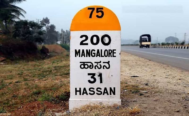
Orange strips on village roads: If you see an orange strip on a milestone, you are travelling on a rural road. At present, the length of rural roads stands at 3.93 lakh km. The orange strip also represents the Pradhan Mantri Gram Sadak Yojana.
What is ‘zero mile centre’?: ‘Zero mile centre’ was the spot British used as a reference point to measure distances to all other cities. Nagpur served as the ‘zero mile centre’ and thus served as the geographical centre of colonial India. This centre has four horses and a sandstone pillar that contains a list giving the exact distance by road to India’s major cities.